Korcula Old Town Fishbone Street Pattern – Medieval Urban Planning Explained
Most visitors to Korcula Old Town spend their first ten minutes convinced they are lost. The streets curve, branch, and double back in what seems like a medieval maze with no logic. Then someone points out the pattern — and suddenly the whole town makes sense. Korcula Old Town was planned, not grown. Its street layout is one of the most sophisticated examples of medieval urban design in the Adriatic, and understanding it changes how you experience the place.
What is the Fishbone/Herringbone Pattern?
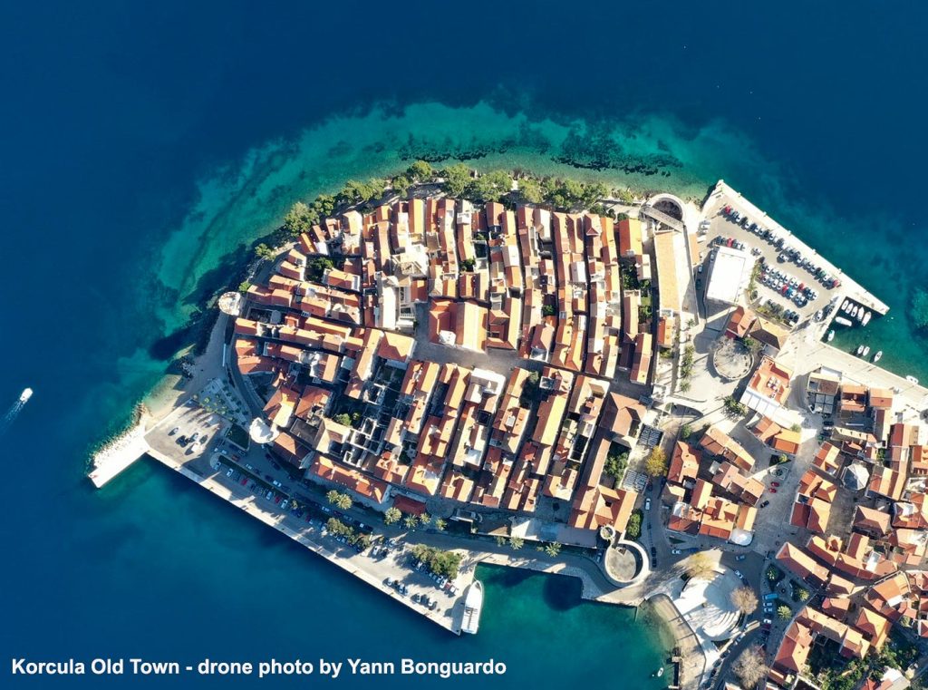
Stand at the top of the Old Town, at St Mark’s Square, and look down towards the sea on either side. To the east, the side streets angle slightly south as they run towards the water. To the west, they angle slightly north. Both sets of streets meet the central spine — the main north-south street that bisects the town — at slightly oblique angles rather than right angles. From above, the layout resembles a fish skeleton: one central spine with ribs angling off in alternating directions. This is the herringbone or fishbone pattern that town planners and architects have been writing about for decades.
It looks organic. It is not. The entire layout was planned and executed in a single rebuilding of the town, most likely in the 13th or early 14th century during the period of Venetian influence. The UNESCO World Heritage documentation — Korcula Town is on Croatia’s tentative list — describes it as one of the finest examples of late medieval urban planning in the eastern Adriatic. Locals and UNESCO alike call it the fishbone – or herringbone – pattern.
Why Were the Streets Built This Way?
The angled streets were not an accident of terrain or gradual accumulation over centuries. They were a deliberate response to two specific problems that any town on a small exposed peninsula in the Adriatic has to solve: wind and sun.
Wind management: Korcula sits in the Pelješac Channel where two significant winds regularly blow. The Maestral comes from the north-west in summer afternoons, bringing welcome cooling. The Bura comes from the north-east in winter, cold and sometimes violent. Streets running exactly east-west would funnel both winds directly through the town, making the alleys uncomfortable and dangerous. By angling the side streets slightly — not running parallel to the wind but not running against it either — the medieval planners created a layout that allows air circulation without creating wind tunnels. The summer Maestral cools the town; the winter Bura is broken by the mass of buildings before it can pick up speed along any single street.
Sun protection: The angled streets also mean that at no point during the day does direct sunlight shine straight down the full length of a street for long. The buildings on either side cast shadows across the narrow alleys for most of the day. In a Mediterranean town without air conditioning — which describes Korcula for most of its history — this matters enormously. The streets are naturally cooler than open plazas, and the shade moves predictably as the sun tracks across the sky.
As one local walking guide puts it: once you understand the fishbone (herringbone), you stop thinking of the town as a confusing maze and start reading it like a plan. Walk south from anywhere, and you hit the main spine. The streets on your left angle one way; the streets on your right angle the other. You can always orient yourself.
The Street of Reflection
There is one exception to the pattern worth knowing about. Running along the south-eastern wall of the Old Town is a street without steps — the only flat street in a town otherwise entirely built on stepped alleys. In Croatian it is called Ulica Kala dei Pensieri — the Street of Thoughts, or Street of Reflection. The name comes from the fact that, unlike every other street in the Old Town, you could walk this one without watching your feet. You could look up, think, reflect. The name has survived for centuries and the street still runs flat along the wall today.
Popular Routes: Split to Korcula, Korcula to Split, Dubrovnik to Korcula, Korcula to Dubrovnik
The Shape of the Town
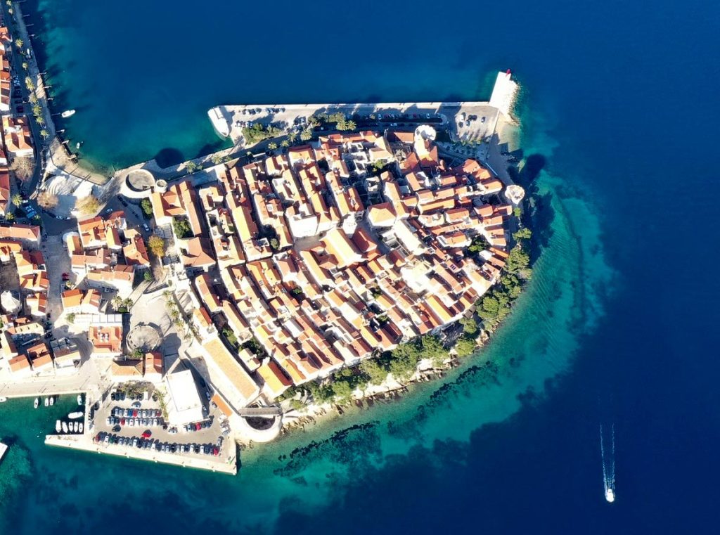
The fishbone (herringbone) pattern works because of the shape of the peninsula it was built on. Korcula Old Town occupies a small oval headland — no wider than 200 metres at any point — that juts north-east into the Pelješac Channel. The oval shape means the town has two distinct sides facing roughly east and west, which is exactly what the alternating angled streets need to function as designed.
The central spine runs north-south, dividing the oval into two halves. The main square — Trg Svetog Marka, with St Mark’s Cathedral — sits at the highest point of the spine near the northern tip of the peninsula. From there the town descends towards the sea on both sides, with the angled side streets creating a series of parallel alleys that run roughly parallel to the long axis of the oval.
Only 15% of the buildings in the Old Town are later than the 17th century. When you walk the streets of Korcula, you are walking where people have walked for more than six centuries, on streets that follow the same plan laid out by medieval Venetian-influenced planners who understood their climate and their site well enough to build a town that still works on its own terms.
Korcula and Chioggia – A Venetian Pattern
The UNESCO documentation makes an interesting comparison. Chioggia — a small town on the Venetian lagoon south of Venice — was also a Venetian colony and was also planned on a fishbone pattern. The difference is that in Chioggia the communication lines between the fishbone (herringbone) ribs are canals rather than streets. The same urban logic, adapted to two very different sites — one a lagoon town, one a Dalmatian island peninsula. Both were products of Venetian colonial town planning during roughly the same period.
There are also parallels with Gothic bastide towns across France and the Iberian Peninsula from the same era, though the UNESCO assessment notes that Korcula’s plan stems from its specific natural setting in a way that distinguishes it from these mainland examples.
How to See It for Yourself
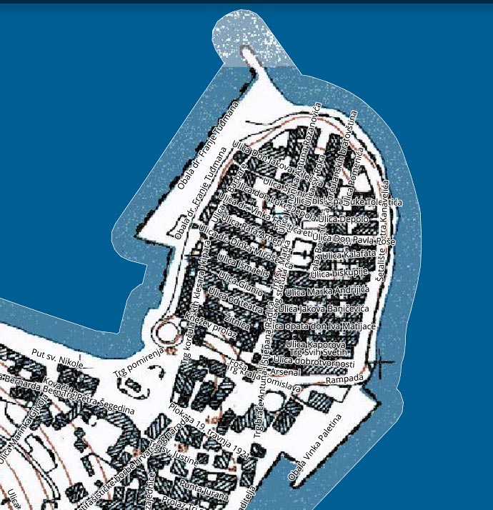
The best way to understand the pattern is to walk it deliberately rather than just wander. Start at the Land Gate — the main entrance to the Old Town from the south. Walk straight ahead along the main spine towards St Mark’s Square at the top. Then turn left or right down one of the side streets towards the sea. Notice how the street angles slightly as it descends. Come back to the spine and try the other side — the angle goes the other way. Do this two or three times and the whole layout becomes clear.
For the best aerial view of the pattern, the bell tower of St Mark’s Cathedral gives a partial overview of the roof level. The full pattern is only visible from directly above – drone photographs and Google Maps satellite view show it most clearly.
The walking tours based in Korcula Town make the fishbone (herringbone) pattern one of their first stops — if you want the full historical and architectural context explained in detail by someone who grew up here, a walking tour is the most efficient way to absorb it.
Related Pages
- Korcula Old Town — complete guide to the medieval walled town
- Walking tours of Korcula — explore the Old Town with a local guide
- History of Korcula Old Town — from Illyrian settlement to Venetian colony
- St Mark’s Cathedral — the centrepiece of the Old Town and its main square